|
Chapter 3
THE GREAT DISPUTE
A. THE CONTENTION
If Knotts Island retains any claim to fame other than its early
discovery and exploration, it is evident in the fabulous boundary
squabble between the colonies of Virginia and North Carolina. Her
day had arrived and now the Island would receive a huge amount of
attention and would appear often in the annals of recorded history
in a fiasco that is exceptionally interesting.
The grant to the Lord Proprietors of Carolina in 1663 set the
northern limits at the thirty-sixth parallel which, if compared on
a map, would place the dividing line below the present sites of
Edenton, Durham, Greensboro, and Winston-Salem. Two years later
the king granted another patent placing the northern limit as a
line to begin at the north end of Currituck Inlet or River, 36-30,
and run due west to Wyanoke Creek. The latter position produced
the rub, while Currituck was a bay running north and south or the
Inlet.(1) "The Inlet in time became reputed as the bounds,"(2).
There was very little concern in the early years over the precise
line and both Virginia and North Carolina granted patents in the
area without the slightest consideration of whose territory was
involved. As the deeds of Lower Norfolk County reveal, many
Virginians held land far into the present state of Carolina.(3).
The need for settlement of the exact line was never pressing until
the residents of the section were taxed by both governments.
The first voice of protest was raised June 12, 1680 in a petition
of the inhabitants of "black water and curratack" sent to the
House of Burgesses and referred to the Committee of
Grievances.(4). As early as May l, 1683 the people of Curretuck
complained to the Council of Colonial Virginia that the North
Carolina officials were "distraining (seizing)" household goods in
the belief they should bear proportionable cost of government.(5).
The inhabitants protested bitterly since they held their land by
patents from Virginia; this was the first attempt North Carolina
made to collect levies.(6).
Virginia had collected taxes far earlier through orders of
September 25, 1680 and May 22, 1683 directing the sheriff of Lower
Norfolk County to collect from "Carrotuck."(7).
The Proprietors of Carolina were quite anxious to settle the
dispute and accordingly petitioned on October 20, 1681 the Lords
Committee for Plantations to appoint commissioners to run the line
between the two neighbors beginning at "Currahtuck."(8).
Virginia's unrest grew as Scottish ships began trading in the
vicinity without payment of duty.(9). Highly indignant over the
matter,the commissioners for managing and levying customs asked
the Lords Commissioners of His Majesty’s Treasury to annex North
Carolina and "Put under the Care and inspection of the Government
of Virginia to prevent shipping of tobacco growing in the South by
Inlets of Corrituck and Roanock." This was the cry of Edmund
Randolph on December 7, 1695.(10).
A year later Randolph again expressed his opinion freely. "Pyrats
and runaway Servants resort to this place from Virginia etc." How
red the explosive gentleman's face must have been when in 1728 the
territory was found to be in North Carolina! He did leave this
historian valuable information by remarking there were sixty or
seventy scattered families under no regular government.(11).
The last statement of Randolph is too true and therefore a
continuous plague to research in the area. Knotts Island was
almost completely isolated with no local government and only
occasional contact with the outside world. Our only insight into
the Island's history is the seldom focus of a major event upon the
isolated land.
Still Virginia sought to collect the taxes in a determined manner
whereby the sheriffs were ordered to appear before the General
Court to answer charges of neglect in the collection of the
quitrents and "other public dues."(12).
B. ATTEMPTS AT SETTLEMENT OF THE BOUNDARY DISPUTE BETWEEN VIRGINIA
AND CAROLINA
In the course of the passing years Currituck Inlet became reputed
as the starting point of the boundary line, but Virginia denied
existence of the second (1665) charter which described the line in
terms of natural objects. On the 19th of March, 1692 Thomas Milner
arrived at Cowpenpoint (altitude 57-20, latitude 36-28) on the
north side of Corotuck Inlet and observed by "My Instrum
(instrument) that a line running due west, as the charter
prescribed, went thence "Over Knots Island leaving the greatest
part of that Island on the South side (Carolina)...but could from
thence make no farther observations of the bearing of any
remarkable Settlemts Contiguous to the place."(13).
The first part of the official report of Surveyor Milner is very
clear, but the after phrasing deserves comment. Milner stated he
was unable to actually carry the line from Cowpenpoint for want of
any "remarkable (notable) Settlemts Contiguous (touching; near) to
the place. " By this it appears no settlers were to be round on
Knotts Island or in the locality at this time - 1692. This is not
likely and in all probability his "remarkable settlement" must
have been a town. The absence of a town does in no manner infer
absence of people.
The statement of Edmund Randolph in 1696 mentions sixty or seventy
families while the wills or Thruston and Walk prove the existence
of settlers.(14). The complaints of the people to the government
of Virginia must have been made, if we believe Milner, by ghosts.
The matter became more and more acute and in 1710 honest efforts
were made to end the controversy when Virginia sent Philip Ludwell
and Nath Harrison as commissioners to meet with Carolina
commissioners, who were not fully instructed, at Currituck Inlet.
On May 27th they secured a guide at the home of Captain Moss
(designator or Moss' Point, Princess Anne County, Virginia) to
lead them to Solomon White's whose home was to be the meeting
place of the arbitration.(15).
Ludwell and Harrison rode "5 mile down Knots Island to the place
where we must take (to) water ...." Here the horses swam about
three-quarters of a mile over "3 channells" arriving then on the
south side of the inlet at the cabin of Thomas Williamson who
lived at the Sand Banks just by the sea side. Here they lodged for
the night and with the dawn swam their animals over Curratuck
Inlet "which is about a mile broad (hardly so much at the
mouth.)"(16). It is most fortunate that the charter of Charles II
was so specific in naming an inlet as a starting point.
The above description of crossing Knotts Island (Currituck) Bay is
proof of that body's danger at that time as compared with a
crossing today across one channel. The waters, it would appear,
are in constant change.
A simple bush or red berries and evergreen leaves greeted the eyes
of the Virginians on the north side. They knew it as Yaupon or
Cassena which the Indians and inhabitants esteemed good for fever
and cold, while in England it was used very widely as an excellent
tea.(17).
The two men erected their instruments and recorded the latitude as
36 degrees, 41 minutes, but here failure entered with the arrival
on June 6 of the Carolina commissioners. Neither side could agree
on the accuracy of the instruments and the mission ended. The
variations in minutes were very important, for the reader will
remember Thomas Milner reported the latitude as 36-28. The
Carolinians' complaint was well founded.
Governor Spotswood informed the Lord Commanders of Trade on July
21, 1714 that Governor Charles Eden of North Carolina had no
instructions from the Lord Proprietors for a settlement.(19). The
attempt of 1710 did afford the officials the difficulty of
carrying a surveyor's chain as Spotswood termed it. "One of the
most unhabitable and impracticable wilderness that is known in
these parts..." refers to the entire route from Curratuck to
Wicconi", but this blanket statement reflects only on the swamps
and not the mainlands.(20).
The testimony of William Duckenfield on May 26, 1711 tells of his
visit to Milner at Nansemond where they discussed the dividing
line. Milner remarked that it would cut exactly through Patrick
White‘s lower plantation on Knots Island.(21). This description
was based on Milner‘s investigation of 1692 and thereby disproves
any claim of total uninhabitation on Knotts Island.
C. THE DIVIDING LINE CROSSES KNOTT'S ISLAND. MARCH, 1728
Virginia‘s Executive Council acted November 1, 1715 by proposing
to the governor of North Carolina a speedy determination of the
boundary question. The Old Dominion agreed to accept the mouth of
Corrattuck River or Inlett as a starting point and from there the
line would run and "be ever deemed the dividing Line between
Virginia and Carolina."(22).
In 1715 Virginia also approved the existence of the second charter
given the Lord Proprietors which charter she had heretofore
denied. As each day passed it became more and more evident that a
decision must be reached if the inhabitants of the thirty-one
miles of disputed land (36 to 36-30 degrees) were to be secure in
land grants. The realm of government moved slowly then as today
and thirteen more years passed before negotiations and pleas
developed into constructive action.
The remaining argument was not over the starting point or eastern
part of the line, but rather over the location of Weynoke Creek.
At this point one of Virginia's most illustrious citizens entered
the scene and enacted his large part in the history of Knott's
Island. Not only would William Byrd serve as a commissioner, but
as an author in recording a history of the venture in his diary.
Byrd's history is a classic as was he. His is a social history of
the English coffeehouse type personified so vividly in Addison and
Steele's Sir Roger de Coverly. The attacks on Byrd's writings have
been hot and heavy mainly because of a secret history appearing
alter the regular one in which he expressed deep personal views.
The purpose of the secret paper was not to ridicule the
Carolinians, but his fellow Virginia travelers.(23).
The author has been criticized, even before completion of this
writing, for even considering William Byrd as a source. The slur
was based on Byrd's unfavorable remarks against Carolina. This is
far from the truth, especially in his remarks about Knotts Island.
More time is spent directing remarks against William Mayo and
Alexander Irvine, fellows of Byrd. For insurance there remains the
Colonial Records of North Carolina which solidly support Byrd‘s
treatment of Knotts Island.
Byrd was accompanied by his fellow commissioners, Richard
Fitzwilliam and William Dandridge members of the Virginia
Executive Council, who on March 2, 1728 arrived in Norfolk.(24).
An attempt to find someone familiar with the land around Coratuck
Inlet was vain until they accidentally met William Williams "that
lives upon the Borders drew a rough Sketch..." of the area and its
routes of accessibility.(25).
By foot and cart they arrived at Prescot Landing on the North West
River where they camped for the night.(26). The environment was
abominable to Byrd as he referred to it in a letter to Charles,
Early of Orrery, as "Worse air, if possible, than in Zeeland
(island of East Denmark)”.(27).
The expedition survived the night and descended North West River
for eighteen miles where it empties into Currituck Sound. The
troop found interest in noting the river never ebbed and flowed
until 17l3 "When a Violent Storm opened a new Inlet (new
Currituck) about 5 Miles South of the old one Currituck as
mentioned in the king's charter...."(28).
Now situated at the junction of North West River and Currituck
Sound, the Byrd polar (line) expedition on the 5th found it
necessary to shape their course around the south end of Knots
Island since a passage to the north of the Island was blocked by
the Great Marsh. While braving the Sound, the commissioners
observed to the south Bell's and Churche's Islands both of which
are known today as gunning sites.(29).
In addition they noted a New England sloop trading without payment
of duty (penny a pound for tobacco.)(30).
The Virginians arrived at the south shore of old Currituck Inlet
and on the 5th of March, 1728 the Carolinians were met, but
unfavorable weather delayed immediate action.(31).
A horrible sound fell upon the ears as the heavy breakers washed
over the inlet which proved to be very shallow and not quite a
mile wide. Deductions led Byrd to believe it had formerly been two
miles across; even with the narrowing the shoals ran out to the
east, into the Atlantic, for two or three miles.(32).
Philip Ludwell and Nath Harrison eighteen years before had
marveled at the red and green Youpon bush; this holly type plant
attracted Byrd with equal enthusiasm. The author believes Colonel
Byrd had tongue-in-cheek when he remarks the natives value shells
"far beyond Gold and Silver." These items were far too numerous to
be counted as specie and what store keeper or tax collector would
receive them in payment? If one has roamed slowly along the beach
of North Carolina's sand banks, there is little doubt but that the
numerous varieties of shells appeared a great deal more colorful
than money.
The North Carolina commissioners, Chief Justice Christopher Gale,
John Lovick, Edward Moseley, and William Little, exchanged
instructions with the Virginians as Moseley, the Carolina
surveyor, set the latitude as 36-3l.(33). Byrd‘s secret history
notes the same on March 6th.(34).
No longer can one row to an oyster bank and secure a meal as did
one of the commissioners who secured the animals described by Byrd
as the largest and best he had ever seen.(35).
That afternoon William Mayo found the latitude to be 36-31, but
Alexander Irvine staunchly insisted it registered 36-30.(36). Byrd
in his 36-31 claim noted a three degree variation in his secret
diary.(37). His secret account violently assails Irvine, a
professor at William and Mary College, but the peak was not
reached until the expedition reached the western end of the line;
then the Virginia political scene was shaken.
Again and again minor occurrences interrupted the proceedings, but
they were in no manner minor to the commissioners each of whom
sought to return the larger slice of land to his colony. They
would fight over grains of sand rather than submit, for what were
words compared to inches of land? Virginia claimed the end of the
sand split of the inlet as the legal starting point while North
Carolina maintained it to be the high land on the north side of
the inlet. Faced with a legal document of 1712, the Virginians
realized they were compelled to recognize the Carolina
contention.(38).
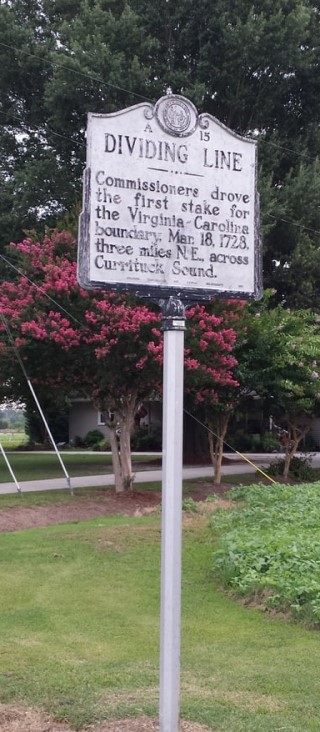
A most important date was etched in Virginia-Carolina-Knotts
Island history on March 7, 1728 as the joint commissioners ordered
a cedar post set in the sand as starting point No. One on the
dividing line between close friends who were often rivals.(39).
Before continuing with the line that would leave the inlet and
move westward, Byrd reported a nature boy or marooner living on
the south side with a "wanton Female" in an Indian bower. They
followed the Bible, Byrd commented, by never spinning nor sowing,
but instead they feasted on oysters and the milk of neighbors'
cows she herded to their door. For clothing nature provided beard
and hair.(40) This is of no credit to Knotts Island, but if the
truth were known, it would reveal their origin as Virginia without
a doubt.
"That day (7th) the Line was run as far as Notts Island about 20
Rodds (330 feet) to the Northward of Wickers House and so cross
the Island ...."(41). The line cut Dosier's Island (Dansiers
Island according to the North Carolina record) a flat sand island
of shrubs lying in Knotts Island Bay (Deal's Island today) and
split the plantation of William Harding.(42). Here they camped for
the night spent on Knotts Island.
Harding had been a valet to Governor Hyde (1710 – 1712) and Mrs.
Harding a laundress near London‘s Temple Bar.(43). Surely
fastidious Byrd had a night of pleasure recalling old England's
peaceful life.
The soil of Knott's Island was highly lauded by the gentleman from
Westover who described the place as forming a wedge with the south
end several miles across and the north end a point. A paradise
existed for stock by virtue of the swamps and warmth with the
sheep found to be as large as Lincolnshire since they suffered
from neither hunger nor cold.(44).
The line left three hundred and fifty acres "Upland of the Island
in Virginia and two Families, the rest of the Island taken into
Carolina..." with five miles in length joined by Jones's (Mackey)
Island on the west containing 2000 acres and half a score of
families (on Knotts Island, not Jones's Island) "thereby taken
into Carolina that before were in Virginia." Thus after sixty-five
years the inhabitants knew to whom to pay taxes. O, the power of
the tax!
The census above divulges twelve families living on the Island
engaged in farming and stock raising with sea food a side
industry. Only three names or those twelve remain for us today:
William Harding and wife, a Wicker, and a Mr. White the principal
freeholder who kept open house for all travelers, shipwrecks, and
debtors.(46).
The dividing line fell on the highland with the distance
across the Island less than half a mile where the line then
entered the Great Marsh and Back Bay (map, page 24). The
Carolinians noted that "Notts Island improperly so
called..." for in reality it is a peninsula extending from
Princess Anne County with water surrounding it only at very
high tides or overflowing marshland.(47). Byrd, too,
III. THE GREAT DISPUTE
observed this and predicted it could be
drained into a productive meadow capable of grazing more cattle
than Job. The climate was almost perpetually warm, but mosquitoes
were infinite and fierce.(48).
SURVEYOR’ S MAP OF BOUNDARY LINE RUN BETWEEN VIRGINIA AND
CAROLINA
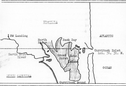
Drawn by E. Moseley, Surveyor General of North Carolina, who was
one of the Carolina commissioners sent to meet the Virginia
commissioners at Currituck Inlet from whence the dividing line
was run due west in the year 1728.
Reproduced from William Byrd's Histories of the Dividing Betwixt
Virginia and North Carolina with introduction and notes by
William K. Boyd, pp. 322 - 323.
On the 8th the baggage was sent around the south end of Knott's
Island to meet the officials at the mouth or North River (Byrd
meant North Landing River.) The party proceeded around the north
end, but encountered something of what Spotswood had
spoken.(49). The shoals promised to wreck the canoe if they had
not sighted a fortune teller and a wench in the Bay as the two
fled from Princess Anne County after expulsion for crafty
living.(50). The pair thought the commissioners to be officers
and attempted to escape, but in the chase they were caught and
forced to designate the channel through Back Bay to the
mainland.(51). Again Byrd’s eye spied surrounding terrain as he
reported seeing Cedar Island to the north of Knotts Island.
After this harrowing escapade they reached the mainland and
camped at John Heath's.(53). The entire population for miles
around left their occupations to flock to Heath’s plantation to
gaze upon them. Many "rose out or their sick Beds...."(54). From
this point the project marched westward through the Dismal Swamp
and unto the land of Wyanoke. The line was now very plain and
firmly settled with both sides thankful the dispute was behind.
Recently the boundary line was checked to assure all
conclusions, but as the “Map of the North Carolina and Virginia
Boundary from the Atlantic Ocean to the Nottaway River..." begun
November 18, 1886 and completed March 5, 1887 shows, there was
no change in its crossing of Knotts Island.(55).
Knott's Island had experienced its day and once again the
darkness of unknown history closed upon it; since 1728 it has
not returned into focus. Her big day passed away with the
passing into the west of the Virginia-Carolina commissioners.
Nothing world shaking in the foregoing account, merely local
history that affords no contribution to important acts of
history and is itself only a by-product of a greater moment or
event. __________________________________________________
1. Colonial Records of North Carolina, II, 730.
2. Ibid., II, 731.
3. Brief Abstract of Norfolk Wills, I, 147.
4. H. R. Mcllwaire, Journals of the House of Burgesses of
Virginia, 1659/60, 123.
5. Executive Journals of the Council of Colonial Virginia, I,
94, 95.
6. Ibid., I, 95.
7. Ibid., 536, 537.
8. Colonial Records of North Carolina, I, 339, 340.
9. Ibid., I, 439: Executive Journals of the Council of Virginia
op. cit. I, 96.
10. Ibid.
11. Ibid., 467.
12. Council of Virginia, op.cit., I, 340.
13. Colonial Records of North Carolina, I, 385 - 386.
14. See pages 31, 27, supra.
15. Virginia Mag. of Hist & Biog., V, 10.
16. Ibid.
17. Ibid., V, 11. Even today Yaupon is used occasionally on
Knotts Island.
18. Ibid.
19. Letters of Spotswood, II, 71.
20. Ibid., II, 142
21. Virginia Magazine of History and Biography, April 1900, No.
4, VII, 349.
22. Council of Virginia, III, 415.
23.W. K. Boyd, William Byrd's Histories, xii.
24. Colonial Records of North Carolina, II, 744; Boyd, op. cit.,
37 secret history.
25. William Byrd's Histories, 37 secret history.
26. Ibid., 38, regular history.
27. Virginia Magazine of History and Biography, January 1924,
No. 1 XXXII, 33.
28. Boyd, op. cit., 40, regular history.
29. Ibid.
30. Ibid, 42, regular history.
31. Colonial Records of North Carolina, II, 743.
32. Boyd, op. cit., 42 regular history; 44 secret history.
33. Colonial Records of North Carolina, II, 744.
34. Boyd, op. cit., 44 secret history.
35. Ibid.
36. Ibid., 45 secret history.37. Ibid., 44 secret history.
38. Ibid., 47 secret history; Colonial Records of North
Carolina, II, 750.
39. Ibid., II, 746.
40. Boyd, op. cit., 46 regular history.
41. Colonial Records of North Carolina, II, 746.
42. Ibid., II, 571; Boyd, 46 regular history.
43. Boyd, op. cit., 47 secret history.
44. Ibid. 48 regular history.
45. Colonial Records of North Carolina, II, 746.
46. Boyd, op. cit., 48 regular history.
47. Colonial Records, II, 571.
48. Boyd, op. cit., 50 secret history. The Island's future.
49. See page 19, supra.
50. Boyd, 48 regular history.
51. Ibid., 50 regular history.
52. Ibid., 48 regular history.
53. Colonial Records of North Carolina, II, 571.
54. Boyd, 50 secret history.
55. A photocopy of the map is owned by the author and was
acquired April 6, 1951. The original is in the State Department
of Archives and History, Raleigh, North Carolina.
|