|
Chapter 4
THE HISTORY OF CURRITUCK
INLET
A. THE ENTRANCE TO THE COLONY
Mention of Currituck Inlet so frequently in this volume demands
that the entrance into the enclosed sea have space for a separate
history. Its fame is far wider than that of Knotts Island and just
recognition is necessary.
Amadas and Barlowe sought entrance to the inland waters in July of
1584 as they sailed north along the North Carolina' coast. They
entered "The first (inlet) that appeared unto us..." and in
addition there existed at this time four more inlets as shown on a
map well known to every historian as the De Bry map.(1). Named
after the publisher, the map names two of the entrances, Hatorask
and Trinity Harbor Inlets, and clearly marked the others, one of
which lay off Knotts Island - Currituck Inlet. Doubtless the
adventurers explored the inlets appearing on the drawing and in
view of this, perhaps the author should claim l584 as the date of
Knotts Island‘s discovery.
The following year the settlers of Roanoke Island under Ralph Lane
definitely explored and used the Currituck entrance in their
voyage to the northward.(2).
The years faded as far as existing records portray, and soon the
Virginia colony of the London Company was thriving around
Jamestown while Carolina was granted to the six lords in 1662.
Nine years before the charter was granted "Caratoke" appears once
again in history as the route used by the fur trader seeking his
lost sloop.(3). The inlet had then been named after the Currituck
Inlets between 1585 and 1654.
A map of 1671 clearly marks Carotuck Inlet and Milner's record of
1692 sets the altitude at fifty-seven degrees, twenty minutes and
the latitude at thirty-six degrees, twenty-eight minutes.(4)
Location of the inlet was ideal for smuggling as reported on
December 7, 1695 concerning Scottish ships trading without payment
of duty and on March 5, 1728 by William Byrd's account of a New
England sloop trading illegally in Currituck Bay.
The reader must remember that reference to the Inlet at this early
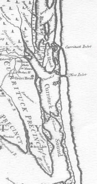
date was of Old Currituck Inlet. Lea's "New Map of Carolina, 1695"
shows the inlet directly opposite Knotts Island affording strength
to the correct location of the break in the sand bank described in
the king‘s charter. (6).Virginia's Executive Journals hold an entry of October 9, 1696
citing the ship "Comodore" at anchor off Corotuck when the "Ruth
and Mary" was seized in illegal trade.(7). The same journal
records the wreck of the "Swift" aground on the south of Corratuck
Inlet.(8). An inlet a mile wide in 1728 and formerly more than two
miles wide, as reported by Byrd, would naturally be the scene of
many shipwrecks, especially with its shoals extending three miles
into the Atlantic as a hidden hazard for the regular lane of
commerce. One type of settler on the Island was doubtless the
shipwreck.
Sea rovers and pirates plagued the merchant ships and instigated
fear in the coastal natives who anticipated an attempt to land and
secure provisions. The Council of Colonial Virginia to counteract
this ordered on May 7, 1700 the chiefs of the militia to appoint
in their counties persons to patrol the sea coast as lookouts. One
of these "beats" was between "Cape Henry and Carotuck”.
The "Garland" was reported lost on November 29, 1709 and a
Spotswood letter or July 27, 1710 noted that three and a half
cables had been saved from the ship near Corrottock for which
Captain Robinson of the "Deptford" was sent to secure.(10). The
privateers were as destructive of shipping as was nature. Their
seizure of vessels kept the inhabitants of the capes in continuous
alarm with their sudden attacks.(11).
One of the widely read pages of North Carolina is the story or her
famous pirates whose boldness excelled the power or the
government. Their shelter from capture was the creeks and inlets
or the coast frequently resorted to after raids on the sailing
vessels many of whom were English, hated more than others for the
strict Navigation Acts. James Logan, Secretary of Pennsylvania,
estimated 1500 pirates on America‘s eastern coast in 1717.(12).
The greatest objection to these vivid adventures was the lesser
custom tills that failed to fill each time a ship fell victim to
the vandals. The Carolina colony designated two custom stations,
Currituck and Roanoke.(13). Both of these were leading inlets and
ideal as collection posts. The coasts of the colony witnessed a
bloody sight on November 22, 17l8 as Thatch was cornered at
Ocracoke Inlet and slain.(14).
B. AN INLET IS BORN
When the federal government, whose seat is in Washington, shows an
interest in an inlet, that location has automatically become
famous. After the closing of the northern inlets in the state, the
salt content of the enclosed sea (Currituck and Albemarle Sounds)
was severely decreased to the extent that the citizens petitioned
Congress to take action to remedy the situation.(15). Along with
the reams of hearings and special reports can be found information
affecting Currituck Inlet.
The chief interest or the committee was Oregon Inlet, but there
existed other inlets "Naming them from the north they were known
as Currituck, New Currituck, Caffeys, and Roanoke."(16). The Old
Inlet "is said to have closed shortly alter l728" and the New
Currituck Inlet closed "about 1828 Or 1835."(17) A statement of a
district engineer on February 10, 1846 says "The second Currituck
Inlet closed about 10 or 12 years ago."(18).
The retaining reader may recall William Byrd remarked that North
West River never ebbed nor flowed until a new inlet was opened
five miles below the old Currituck Inlet in 1713 "When a Violent
Storm opened a new Inlet ...."(19).
More interesting to the geologist than to the historian is the
realm of mastering the intricates involved in the birth of an
inlet. New Currituck Inlet was born when North West River "broke
through...during flood."(20). This was 1713. The Corp or Engineers
deduced that sound water can break through the sand beach in three
ways, viz., flood resulting from heavy rainfall, a heavy northeast
storm, and "some obstruction in the shape of a rising of the
bottom of the sound which would tend to direct flood waters in the
sound."(21). The latter is true of the new inlet since the waters
of North West River rushed through a spot in Currituck Sound
called the Narrows with little resistance.
With the arrival of the commissioners in 1726 Currituck Inlet
reached its fame as those officials stood on its banks and proceed
with the instructions of the charter. Soon to completely close,
the inlet would be succeeded by the new one
which also closed in the beginning of the nineteenth century.
Now ends the complete, known history of an enclosed sea, an
island, and an inlet. All appeared briefly on the state of
historical events and have long since returned to the unknown.
1. Hawks, op. cit., I, 70, 71.
2. See page 3, supra.
3. Colonial Records of North Carolina, I 18.
4. Hawks, op. cit., II, 52 - 53; Colonial History, I, 385.
5. Ibid., I, 439; Boyd, op. cit., 42 regular history.
6. Charles L. Van Noppen, History of North Carolina, I, 145.
7. Executive Journals of the Council of Virginia, op. cit., I, 354
- 355.
8. Ibid., I, 378.
9. Ibid., II, 378.
10. Ibid., III, 228; Brock, op.cit., I, 3.
11. lbid., I, 11.
12. Ibid., I, 118 from Watson‘s Annals, II, 218.
13. Colonial Records of North Carolina, II, vi.
14. Letters of Spotswood, II, 274
15. Senate Documents, 71 Congress, 1st. session, No. 23, 6.
16. Ibid., Report of the Special Committee on Inlets by the
Fisheries Committee Board of North Carolina, 14.
17. Ibid., 15.
18. House of Representatives, 29 Congress, 1st. session, report
No. 25, 3.
19. Boyd, op. cit., 40 regular history.
20. Ibid.; Senate Documents, op. cit., 15.
21. Ibid., 14 – 15.
|