Updated April 28, 2010
Comment - Don Austin: Back in 1961 Sue took me around to many peoples houses to introduce me to family and friends. At someones home (my memory fails me) I was shown a photograph of a schooner sitting across the road from the Methodist Church. The photo was taken from the Church yard. I believe it was a "tin-type" photo. The schooner was docked parallel with the roadway leading to the present school and the whole area on that side of the then dirt road/path was covered with water. Has anyone got that photo or is anyone aware of it?
Comment - Jane Brumley: I was also told by my father (James Nonie Miller) and grandparents (Levi and Pat Miller) that boats landed in the area opposite the Methodist Church. When younger I used to go thru the woods across from the Church and it is very low ground in there. Just notice the elevation of the land from the Methodist Church going North. Very interesting. There is probably some geodetic survey someplace that would clear up this mystery. Did Henry Ansell ever mention such a thing in his writings?
Comment - Natalie Twiddy: My Gramps (Harold O. Capps) did talk about a boat that would dock there on occasion.
April 2, 2010. Comment - Jane Brumley: I met with Emily Capps, just turned 90 years old, this AM. She is from Princess Anne Co. and she said she always heard about boats tying up at the Methodist Church. She also said "remember, in our younger days we did not travel very far from home". She has had a lifelong interest in local history. After taking some pictures over at Morse Point of Flyway and the Thomas Dixon log cabin, I visited Izola Waterfield Bonney. Izola will have an 89th birthday soon. She said her grandmother told her about boats at the KI Methodist Church. Her grandmother was b 1874 and d 1950 and her tomb is in the yard. Izola has lived her whole life in this house which is just East of the KI Cemetary. She described how the water was at the back of her house and went up to the Methodist Church as told to her by her grandmother. We then discussed the road that traveled somewhat north of this "so called water area" to the "landing" which was back of her house. Living near the Methodist Church, I traveled via walking this road with my father (James Nonie Miller) to the landing/pier where he kept his boats. Now, when we speak of roads we are not talking of roads the width of what we have today. More like a horse cart path. I think, we can say, boats did "tie up" at the Methodist Church.
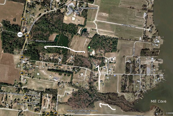
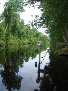
Comment - Gary Montalbine: I think from the responses we can conclude that there was water access to the Church. Unknown - depth, width and direction. Judging by Googlemap above, the entrance was apparently at Mill Cove. Followed what I believe is called Branch Cut. This is near Larry Etheridge and the Brumley house. Crossed Brumley Rd and went up behind the houses to the Church. Route noted by the arrows. Access to S. Brumley Rd. therefore must have been thru Martins and the school. It is conceivable that this path was wide and deep enough in early days for a schooner. Obviously silt over the years has filled in the waterway.
Comment - Brenda Twiford. I was told by my mother (Ruby White Davis) that her father told her that the water came up to the area across from the Methodist church and was used by boats as a method of travel to church.
April 13, 2010. Comment - Diane Karpov: When we arrived home today at Mom's, Mary Waterfield's,we were talking history and Mom said, I remember Daddy taking us kids by boat to church, up that little creek that run's up and over Brumley Rd. She said there was a type of bridge, I think I remember the bridge as a very young kid. I ask her if the water went to the church and she said yes.
Comment - Jimmy Cason: Maurice Waterman would be a good source to ask some of these questions. He knew and remembered Mr. John Waterfield. My great Aunt Helen Waterfield was married to Leonard Waterfield. Leonard's father, John Waterfield, could remember boats tied up in front of the Methodist church. And I believe there was mention of net drying racks on the shore in front of the church. Interesting note, when my Dad was building my cousin Vincent's house on our Grandma Cason's property he was running a ditch-witch across the field to bury cable and hit a ships anchor 18' below the surface. I find this interesting whereas Grandma's property bordered the Mill Cove. I have the anchor and will try to post a picture at a later date. As far as Henry Beasley Ansell's book goes, I do not recall his mention of the boat basin. However he does mention, as I recall, a bridge that crossed a creek. I think the bridge he was referrring to was on Brumley Road where there is now a culvert just west of Larry/Jane Etheridge. Once while I was in Edenton NC I viewed a very old map of Knotts Island. While it was not detailed it showed what appeared to be a waterway running North/South through part of the Island.This waterway appeared to connect Mill Cove to Hollow Tree Branch. Via a path that ran north of the present methodist church towards the school crossing northwest toward Wards Rd. and again north to Hollow Tree Branch.
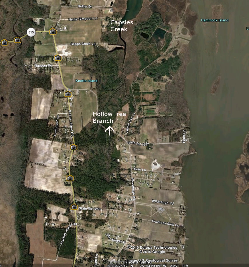
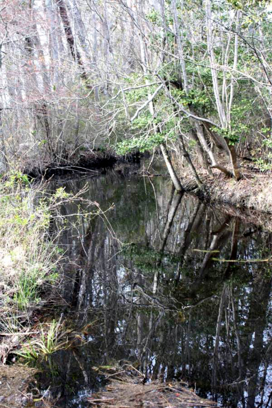
April 25, 2010 Comment. - Jane Brumley: Hollow Tree Branch today. In the last 50+ years it is the sharp curve, going North, just past Simpson's Neck Lane (Knights Point) which is north of the old Jones Store. If you notice there is a large ditch/canal located there. To help with this location there are trees on both sides of this curve and during high tide (which we have now) there is usually some water standing on the road. Buster said this ditch/canal is fed via Capps Creek and goes by/thru the Yarborough property. He said that even today you could possibly get a small boat thru Capps Creek and thru this canal /ditch during high tide. He said that this is not man made but has, since he can remember, always been there as a natural lay of the land. Our house is on Capps Creek and today (3/24/2010) the tide is quite high. And during earlier times some boats used were small compared to our pleasure Back Bay/ Knotts Island boats of today. Hope this helps. Also, Hollow Tree Branch has been considered to be haunted and in generations past not to be traveled during the dark hours. I heard this as a child.
Comment - Jim Waterfield: I always heard that it was named that after gold was hidden in a hollow tree.
Comment - Dorothy Hocutt: In Henry Ansell's book he tells of several haunted places on KI, one of them being on the road through Holly-tree-branch. He also tells a story of Michael Waterfield "who with others found a chest on the sea shore containing a large lot of money. He put a shot-bag full of this coin in the crotch of a tree in Holly Tree Branch for safe keeping and never saw it again."
Comment - Gary Montalbine: On maps I have seen Capps Creek and Capsies Creek.
Comment - Jane Brumley: Well, that is an interesting question. On the current map that we use when we are boating has Capsies. Also, Bullocks hole is spelled wrong. I guess use either one until we can document on a very old map. I think Capsies came about because different people were spelling and many years ago could not read or write. I think they meant to spell Capps's showing possession. Capps is a very old Island name and a Capps at one time owned more acres than anyone else around here. In working on lower Princess Anne history we have come upon many different spellings for people and locations. I think if you are trying to document something just use what is spelled in that material. So I would do it this way Capsies (Capps) Capps (Capsies) depending on what was being discussed.
Comment - Gary Montalbine: I vote for Capsies. It's more in keeping with Knotts Island.
This link contains an 1867 map of the Albemarle and Chesapeake Canal and the Dismal Swamp Canal
April 28,2010. Comment - Brenda Twiford: In 1808, Secretary of the Treasury Albert Gallatin conceived the idea of an inland waterway from Massachusetts to Georgia that would allow protected north-south transportation and avoid the need to travel on the open ocean. The waterway would consist of rivers (many of which would have to be deepened or widened), bays, inlets, and canals. His plan didn’t find much support until the British blockaded the U.S. coastline during the War of 1812. Most people and politicians at that time had been opposed to the national government building roads, but the difficulty of transportation during the war made it a matter of national defense. With funding from Congress, a feeder canal was built connecting the Dismal Swamp to the Northwest River and Currituck Sound. But it would be more than a hundred years before Gallatin’s dream of a full intracoastal waterway would be realized. Dismal Swamp Canal As use of the canal grew, it had to be deepened and widened to accommodate boats that could navigate the Albemarle and Pamlico Sounds. With more money from the federal government, the entire canal was rebuilt. Over time, more locks were added — bringing the number from two to five — and new stone locks replaced the old wooden ones. By 1828, the Dismal Swamp Canal averaged 40 feet wide and could accommodate larger boats. Even so, passage was slow. The stone locks frequently broke, and boats might have to wait for days while the locks were repaired. In 1859, the Albemarle and Chesapeake Canal opened, and this new route — which provided faster and more reliable transportation for larger vessels — took away most of the Dismal Swamp Canal’s traffic. In the 1890s, the Dismal Swamp canal was rebuilt again, this time with only two locks, and for a time it again carried commercial cargo. But in 1913 the federal government bought the Albemarle and Chesapeake Canal as part of the new toll-free Intracoastal Waterway. The Dismal Swamp Canal couldn’t compete, and in 1929, it too was purchased by the federal government and added to the Intracoastal Waterway. Today, the Atlantic Intracoastal Waterway — made up of rivers, inland bays, inlets, and canals maintained by the U.S. Army Corps of Engineers — provides a protected inland channel for recreational boaters and commercial shippers from Norfolk, Virginia, all the way to Miami, Florida.