|
KNOTTS' ISLAND: ITS GEOGRAPHY
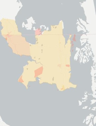
If you will look at the map of North Carolina you will find that
Currituck County covers the northeast portion of this map, and by
looking at the northeast part of this county map you will see what
looks like a square piece of land as if it had been belched forth
from the State of Virginia. The western portion of this Island map
is the Great Marsh three and half miles across to Morse's Point.
This marsh with its knolls and Mackey's Island help to make up
this apparently square island map. Knotts Island proper, though,
only covers the eastern portion of this square, averaging scarcely
more than one mile in width from the bay on the east to this Great
Marsh on the west. This Island has always been called seven and
half miles long & its area can not cover much over that many
square miles. About five miles of this Island is in North
Carolina, the remainder in the state of Virginia. The space
between this Island and the Atlantic averages from two to four
miles, made up with bays, marshes, hummocks, creeks and the sandy
seashore; the latter is interspersed with "Washwoods" and other
timbered sections; and a channel penetrating the whole length of
the Island connecting Long Island Sound in Virginia on the north
with Currituck Sound on the South.
There was once a deep creek that entered this Great Marsh, North
of Mackey's Island and ran through the Barl's Island Bay, making
this Island knolls &c. an Island proper; but this creek called
Back Creek has so filled up that a person can walk from the Island
to Morse's Point, in a dry time, without crossing the bridge that
span it. This creek never afforded much water where the marsh road
crosses it, for the surveyors in their report said so in 1728,
when the line between Va., and N. C. was ran & settled.
The soil of this Island is a light sandy loam, sand
predominating; excellent trucking land, but even now little used
for that purpose other than home consumption, yet, I believe some
progress is making in that direction. There is no more suitable
place in Currituck County for trucking than this Island, and why
the whole place is not a truck garden has often staggered the
writer.
But recently the writer was informed why the people did not
extensively follow this modern industry, was on account of
uncertain transportation. Yes, and the same thing works a serious
wrong to all the trucking sections of this county, as well. The
Island, owing to its soil and situation has always been famous for
peaches, apples, cherries and many other fruits. In past days in
orchards and yards there were plenty and to spare of all these
delicious fruits and they were free to those who would help
themselves.
About this Island by the sea.
This book of tales will tell;
The people there alert and free,
In blissful vein cloth dwell.
It's daily washed by bay and sound,
Its shores sometimes in sea,
It extends due north of our sound,
Into Virginia
The west may boast of mountains grand,
Their peaks and gorges show,
But mountain sandhills here we have,
On the Atlantic shore.
The old Atlantic's stormy swell,
When rushing to its strand,
There's nothing more romantic,
When it breaks upon the sand.
Come now ye lads your sweethearts take,
And place them on these peaks,
Their eyes agazing oceanward,
The breakers at their feet;
The moon now flashing diamonds,
On ocean's frothing crests
Pop the serious question boys,
They'll likely answer yes.
Then away with lengthy courtships,
These sandhills being near,
With pockets lined with green-back bills,
The license never fear.
Back to the top.
|