Barge Graveyard
The intra-coastal waterway has been maintained for decades as a route for commercial marine transportation. The steel barges you now see navigating the "ditch" used to be made of wood and had a limited life span. We found an "ox bow" near Knotts Island that was used as a mooring station for old barges that eventually sank to for the barge graveyard.
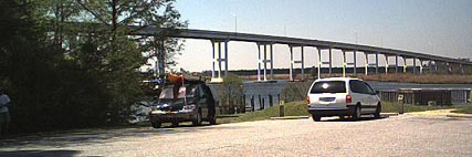
To get to the put-in point you go to the end of Old Pungo Ferry Road. It's situated exactly North of Pungo Ferry Road and can be found easily at Mapquest.com. There is parking and a sandy spot to access the water. You can see where the name of the road comes from now.
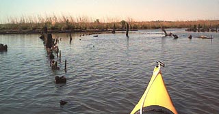
After you get underway, cross the waterway and head south by turning right along the shore. You will come to a creeks on your left. Pass them until you come to one with a navigation marker on it, the fourth one down. Head into this and you will immediately see the frames of the old barges resting in the marsh to your left.
Be careful of large boat traffic as you cross and navigate the waterway. Many yachts use this route on their migrations to warmer climates and the operators are not courteous enough to slow down for smaller vessels. Nor are they intelligent enough to heed the "NO WAKE" signs posted prominently in this area.
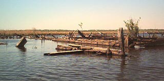
You can poke around in here but be careful of the iron fittings that are still in the big wooden frames and timbers. They can put a pretty good scrape in your hull.
 .
.
This is isn't a very long paddle at all. You can explore the creeks and oxbows around here fro a while after you've seen the barge hulks. There is a marina with a little store within sight of the put in point and Capt. George's Seafood Restaurant is directly next to it as well.